A new project (still in the works) using ESRI’s CityEngine to create a 3-D model of the UW campus in Seattle
.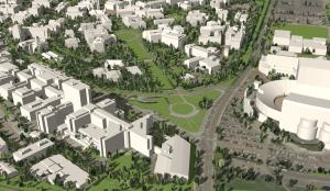

A new project (still in the works) using ESRI’s CityEngine to create a 3-D model of the UW campus in Seattle
.
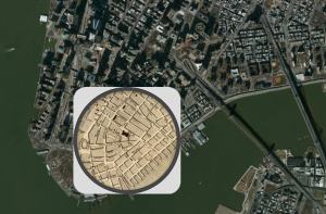
Circular maps strive to better capture residents mental map of neighborhoods.
City Maps That Orient You Better Than Google Can – Kristin Hohenadel (Slate)

WWU alumni complete 4,000 mile human-powered trek from Bellingham to the western Arctic (map by Spatial Institute staff Stefan Freelan)
http://www.windowmagazine.org/window/index.php?section=Stories&id=344

Reid Wilson, The Washington Post
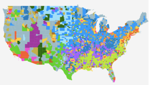
Dante Chinni divided the counties of the country into 15 types of community based on the American Communities Project at American University.
Georgia Strait Alliance and Raincoast Conservation Foundation use crowd-sourced data to predict where oil spills might go.
Help Create Maps of a Potential Oil Spill in the Salish Sea

A tool (helper page) for finding bounding box coordinate values for use with various web mapping applications, designed by Aaron Racicot.
See also ProjFinder (a similar tool for identifying appropriate projections for different locations throughout the world)
Smithsonian Magazine provides archival maps from the David Rumsey Map Collection overlaid with current aerial photography.
See also:
Use of GPS technology may hinder our own ability to form accurate mental maps and actually limit brain development…
Todd Humphreys (U. of Austin’s Radios Navigation Lab) discusses the future of GPS, tracking and unintended consequences.
http://www.ted.com/talks/todd_humphreys_how_to_fool_a_gps.html
http://www.ted.com/talks/todd_humphreys_how_to_fool_a_gps.html